Thursday, October 20, 2016

Family "Coat of Arms"


In response to a recent comment from a reader of this blog as to whether I knew what the Köferli  "Wappen" or coat of arms was, I have a photo from a book on Lengnau, Switzerland, where my Köferli family originated.

 
This page contains the Wappen for the founding families of Lengnau: Angst, Bucher, Jeggli, Köfer, Köferli, Müller, Suter, and Widmer.  Note that there is both a Köfer and a Köferli. I was told that there was originally one family name of Köfer, and the family split, with the new branch taking the same name but with a diminutive “li” ending to make Köferli.  I was also told that the name means one who works with copper, as a barrel maker, which in English is called “Cooper” These names date back hundreds of years, and in searching the Swiss national archives for my family names I found the Köferli name intermarried with Suter, Bucher and Angst over the centuries. Still more genealogy research needs to be done!


Saturday, September 3, 2016

Switzerland on $15 a day...


How did I do it?  Simple, stay with family. Seriously, the only way I have been able to explore Switzerland in any depth has been because I am fortunate enough to have family there.  Otherwise, travels in CH would not be possible within my budget.


After a six month hiatus, I was back in Switzerland enjoying a gorgeous August in Zürich, with weekend day-trips within easy reach.  Near Interlaken in the Bernese Oberland, stopped at Meiringen at lunchtime for a chance to see the Reichenbachfälle, the famous Reichenbach Falls of Sherlock Holmes.


As any long-time fan of Sherlock Holmes can tell you, the Reichenbachfälle is the scene of the final, deadly encounter between Holmes and his arch-enemy Prof. Moriarty, as recounted by Sir Arthur Conan Doyle in the story “The Final Problem.” Conan Doyle was pressed by his publishers to permit Sherlock Holmes to survive the fight, but looking over the precipice at the falls, seems survival would have been doubtful.


Driving through the town of Meiringen, signs pointed to the Sherlock Holmes Museum, in the basement of what was formerly an English church, with a sculpture of Sherlock Holmes in front of the building.  From the town, the Reichenbachfälle is accessible using the Reichenbachfälle-Bahn, the funicular that climbs a dizzyingly steep gradient to the falls. Or one can hike up.  We opted to drive up to the restaurant at Schattenalb for lunch, from where it was a much easier hike down to view the falls, which consisted of three or four separate cascades roaring through the large granite boulders shaded by thickly wooded slopes. 
 
 
Hiking the extent of the falls was made much easier with the many stairs interspersed with viewing platforms with perfect vantage points to take pictures.


There was a small hydo-electric station near the upper falls, and below were signs warning hikers of sudden bursts of water from water released through the dam.  The Reichenbach roared straight down the chasm to the valley below, flowing into the Aare, which flows into the Rhine about 120 Km north.


After enjoying a taste of Sherlock Holmes adventure, we continued on up to the Schwarzwaldalp, past Rosenlaui, and found a fully operational water-powered lumber mill, dating from 1896, complete with a woodman who explained the operations. 
 
Most educational, both the children and adults present were fascinated.


Stopped at the base of the Sustenpass at Gadmen to buy some alpenkäse in a roadside shop.
 
 Then climbed up the switchback road across the pass, and got a photo of the signpost at the summit (2224 meters above sea level). 
 
The snow was real, and saw a glacier feeding a mountain lake on the way up.


The return through canton Uri was some of the most beautiful mountain scenery and classic Alpine towns in Switzerland. 

Monday, February 1, 2016

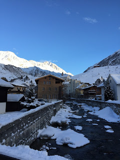
Winter in Andermatt, Switzerland


A serene Alpine lake at Innerthal


Naturally I’m back in Switzerland, staying in Zürich for as long as the authorities (and my family!) allow. The weather before New Year’s Day had been mild, but in mid-January the snow and cold of a real winter arrived.
Andermatt, the perfect Alpine resort

We decided to take a day trip to the Swiss Alpine town of Andermatt, one of the lesser-known ski resorts, certainly not as famous as Zermatt, Gstaad, or Davos, but just as gorgeous.  Andermatt, in the heart of the St Gotthard Massif, lies at an altitude of over 4700 feet on a crossroads between the mountain passes of St Gotthard, the Oberalp, the Furka, and The Göschenertal. This Alpine valley in the Canton Uri is the source of both the Rhine River, which flows into the North Sea, and the Rhone River, which flows into the Mediterranean.

St Michael Chapel in Andermatt, with an ancient Gothic baptismal font inside

Driving through the 10.5 mile long St Gotthard Road Tunnel, which opened in 1980, is a radical switch from the German Swiss to the Italian Swiss. One enters the north portal of the tunnel at the town of Göschenen, in the Canton Uri, and exits the southern end at Airolo in the Italian speaking Canton Ticino. As with many tunnels through mountain passes (such as the Eisenhower Tunnel in Colorado) the weather at one portal can be entirely different from the other, that is, one can enter during a blizzard, and exit into the sunshine.
A bridge in Andermatt over the Interalpreuss

Andermatt had always been an important staging post on the ancient St Gotthard Pass, resulting in the development of several hotels and transport services. In the 19th century a Swiss Federal Army barracks was located in Andermatt, further expanding the local economy. But with the opening of the St Gotthard Road Tunnel in 1980, which bypassed Andermatt, many hotel businesses closed or were converted to barracks for the remaining army training functions. However, Andermatt is well worth a detour if driving from Zurich to Lugano, or as its own destination, as it is an easy hour’s drive from Zurich.  And what breathtaking scenery!

Skiers and snowboarders at dusk
 
Of course, the two ski areas above Andermatt have ski lifts running up from the village, and the public transportation serves the lifts from the several hotels. This village is an authentic ski town, what the ski resorts of Vail and Aspen in Colorado were designed to emulate.


The Chedi Andermatt

Andermatt is undergoing significant upgrades with the recent addition of The Chedi Andermatt, a 5-Star hotel, conference center and spa. The Chedi opened in 2013 to some controversy, as introducing such a world-class attraction, even if a boost to the tourist industry, may cause excessive strain on a delicate alpine environment.  However, the developers made a great effort to create a facility with minimum environmental impact, and employ an architectural style that melds the traditional alpine ski chalet look with ultra-modern 5-star amenities.

Cozy time for aperitifs!
 
We had lunch in one of the many dining rooms, and after taking a walk around Andermatt, returned to The Chedi for aperitifs in front of one of the several roaring fireplaces. What luxury!  From the windows we could watch the sunset on the snowy peaks surrounding Andermatt, a joy to behold.

Breathtaking sunset
 
If planning to visit Andermatt, check out the village website:  www.andermatt.ch, and for a luxury lunch, try  The Chedi Andermatt at  www.ghmhotels.com


Tuesday, July 21, 2015

Swiss Confederation and Charles the Bold

Murten Castle, Switzerland

On 1 August the Swiss celebrate their National Day, commemorating the “Oath of Rutli” in 1291 when the leaders of the Cantons of Uri, Schwyz, and Unterwalden met to pledge their mutual cooperation to form what became the Swiss Confederation. Many shops and stores have a supply of Swiss flags and items decorated with the Swiss insignia, the white cross on a red field, much as shops in the USA stock “Stars and Stripes” flags prior to 4th of July.


Gruyères Castle
With over 800 years of history, one may think the formation of the Swiss Confederation was a relatively peaceful endeavor.  Far from it. The Swiss have had to fight for their independence every step of the way, engaging in wars over the centuries with the Kingdoms of Savoy and France, the Habsburgs of Austria, and the Duchy of Burgundy.

The Burgundian Wars, in particular, were quite dramatic, and in the end the defeat of Charles the Bold, Duke of Burgundy by the Swiss changed the course of European history, as cliché as that sounds. Of the three last crucial battles of the Burgundian Wars, two of the battlefields are in Switzerland, and I decided to visit one, the site of the Battle of Morat (or Murten in German), fought on 22 June 1476.

After an easy 2-hour drive from Zürich, I reached the medieval walled city of Murten, surrounded by modern industrial zones, which I tried to ignore. I walked through the gravel gardens outside the city walls by the Schloss, past a large chessboard, to look out at the lovely Lake Murten, a view enjoyed by other visitors eating their lunch. The courtyard of the Schloss Murten was open, but the interiors, used as city offices, were not accessible.


I was able to climb the rampart walls to stare out to the landscape southwest of the town that had been the battlefields in 1476, where the sight of Burgundian tents, the infantry, and artillery were now replaced with green fields and leafy forests against the hills.
 
 
After wandering through the city, I visited the Murten Museum, which contained exhibits of 6,000 years of life in this region, starting with the La Tène culture pile-dwellings found on the Murten lakeshore. However, my focus was on the Battle of Murten, and I studied the display cases of weapons, armor, and cannon from the battle, along with a skull showing a clear slash-mark from a sword.
 
The 17-minute video explaining the battle was given in French and German (this being a bi-lingual city), and I was almost able to follow it.  As I was leaving, I purchased a book about the battle, and chatted with the young student at the entrance desk, speculating how European history would have been altered had the battle been a victory for Charles.  For example, I don’t think the marriage of his daughter Mary the Rich (Charles’s only heir) to Holy Roman Emperor Maximilian would have taken place, thus the Burgundian Netherlands would never have become part of the Habsburg Austrian Empire, nor would the Order of the Golden Fleece been taken over by the Habsburgs. The loss of Swiss territory to Charles, along with the combined dominance of Burgundy and Savoy over the Swiss cantons, may have eroded the strength of the Swiss Confederation, perhaps even ending the dream of a federated Switzerland. There might not be a country called Switzerland today. And, in Charles’s quest to enlarge and unite his Burgundian territories, he may have succeeded in creating a kingdom for himself, which may have survived to the modern age -- a nation called Burgundy? Imagine, the name Burgundy would be more today than just a fine French wine.

Cape of Philip the Good, Duke of Burgundy
15th Century Burgundian armor
I took a detour to visit Gruyères, the Swiss city famous for the cheese, which was about an hour’s drive east. My goal was not so much the cheese as to visit the Castle of Gruyères, which holds some of the booty from the Battle of Murten. In my tour of the castle, I entered a large room containing four display cases, one with suits of armor, and three that held large black velvet capes with gold-embroidered coats of arms of Charles the Bold and his father Philip the Good, the last two Valois Dukes of Burgundy.  Amazing, these cloaks were almost six hundred years old, and still attested to the elegance, culture and wealth of the Burgundian court, the most splendid in Europe.


But Charles was vanquished at Murten, losing almost 10,000 of his army to the 400 Swiss causalities, and at the Battle of Nancy in January 1477, finally lost his life.  The young man in the Murten museum told me a doggerel verse all Swiss schoolchildren learn:  “Karl der Kühne velor, bei Grandson das Gut, bei Murten den Mut, bei Nancy das Blut” meaning "Charles the Bold lost at Grandson his goods, at Murten his courage, at Nancy his blood."  Whoa.

Street scene in Murten
The defeat at Murten and eventual failure of Charles the Bold to make himself king had far-reaching consequences.  In the land-grab that followed, France and Germany (the Holy Roman Empire) embarked on centuries of warfare for control of the of the Burgundian territories, from the wars of French King Louis XIV, to the Franco-Prussian War, to the First and Second World Wars. In addition, the Netherlands fought the Eighty-Years War against the Spanish Habsburg kings for independence.  However, with their victory over the Burgundians and Charles the Bold, among many other military victories in their 800 years of history, the Swiss can celebrate their National Day this 1 August.

Sunday, July 12, 2015

Swiss Skyline


The Eiger (3970 m), the Mönch (4099 m), the Jungfrau (4158 m) – Swiss mountain peaks famous in literature, movies, and mountaineering lore.
Met with Helen and Felix at the Zürich Hauptbahnhof to catch a train to Bern, transferring to Interlaken, and then on a narrow-gauge railroad to Lauterbrunnen at the foot of the trio of gorgeous mountains of the Berner Oberland.

Our first stop was a visit to the amazing Trümmelbach-fälle, made up of ten waterfalls inside a mountain that drain the glacier defiles of the Eiger, Mönch, and Jungfrau, carrying 20,000 tons of rock and gravel per year. This is the only glacier-waterfall in Europe inside a mountain, accessible by tunnels and stairs for visitors. The force of the waterfalls is frightening, up to 20,000 liters of water per second, very cold, and the noise is deafening!

At Lauterbrunnen we caught a series of busses and cable-cars (I lost count by the end of the day) to reach the summit of the Schilthorn (2971 m), to have a picnic lunch near the revolving restaurant Piz Gloria, a location used in the Bond film “On Her Majesty’s Secret Service.”
 
The weather was perfect, warm and sunny, and both outside and in the 360˚ revolving restaurant, we could only marvel at the majestic scenery of the spectacular panorama of the Swiss Skyline, the Eiger, the Mönch, and the Jungfrau. There were well-marked hiking trails for exploring flowery alpine meadows and permafrost fields along the glaciers, and, of course, many peaks for technical climbers.  For those who just want a minimum of exertions for a coffee and to shop, the Piz Gloria works nicely.

On our way down, we stopped in the picturesque village of Mürren, filled with classic Swiss chalets, small hotels and restaurants, and lots of flower gardens. The Eiger in the distance seemed to be watching over all.

Back to Interlaken (the Jungfrau in the distance) for a short walk-about, eyeing all the luxury hotels, and stopped for ice cream at an outdoor café complete with jazz band.
 
Reluctantly, we had to dash to catch the train to Bern, and then back to Zurich.  I lost count of all the trains we had been on, and we counted at least eighteen!  But what a wonderful chance to see what makes the Swiss Alps so world-class famous.

Friday, June 26, 2015

Day hike in Appenzell, Switzerland


Several days ago Felix, my cousin Helen’s husband, invited me for a day-hike to the canton of Appenzell, in the north-eastern Swiss Alps. Appenzell is a small canton that was once part of the canton Sankt Gallen, today is surrounded by it, and has a colorful history tied to the famous medieval Abbey of Sankt Gallen.
Felix, a vigorous and experienced hiker, chose the Ebenalp in the Alpstein as a test of a moderately challenging hike. His plan was for us to journey by train to the Ebenalp, a resort area with hiking trails, cable-cars, and a number of restaurant-hotels. We would explore the area, taking one of the shorter hiking paths to see the Wildkirchli, and have lunch! I was to be the test subject, a proxy stand-in to gauge the difficulty of the hike for the up-coming visit of Felix’s cousin in October.

We met up at the Zürich Hauptbahnhof and caught a train through Winterthur, disembarking at Gossau. Crossing to the adjoining platform, we jumped into a railcar for the narrow-gauge railroad (for the mountain climbs) called the Appenzell Bahnen, to Wasserauen, the last stop on that leg of the Appenzell Bahnen.  The neat, red painted railcars were fitted with large windows for viewing the green fields dotted with villages and farms, and the approach of the gorgeous mountains.

We emerged from the railcar at Wasserauen, crossed the bridge over the clear, cold mountain stream called the Schwendibach, and walked to the Ebenalp cable-car building. Felix got our tickets and we were soon on the cable-car with several other hikers on a 6-minute, white-knuckle ride above the rough granite cliffs. The over 700 m change in altitude caused my ears to pop, but I was pleasantly surprised at my lack of vertigo and was able to get some photos of the green valley receding below.


Wasserauren is at an altitude of 868 m and the cable-car stop was at about 1590 m so we walked up remaining 50 m in altitude to the Berggasthaus at the top of the Ebenalp, alt 1644 m.  The weather was cloudier than I had hoped, and we were not able to see the Bodensee (Lake Constance) in the distance, as had been advertised.  Felix cleverly said, “We viewed the mist, but missed the view!” 
 
However, we could clearly see up to the highest point, the top of the Säntis (2504 m alt) and down to the Seealpsee, the dark blue alpine lake below.  Hiking trails were well marked, and according to the trail map I picked up, most of the peaks had either a restaurant or a B&B.  The Säntis had two!  Of course, the restaurants above were accessible only on foot, but I think the B&Bs on the lakeside of Seealpsee could be reached by car.  A cable-car terminus was near the restaurant and B&B on the Schäfler peak (1924 m alt), but the rest were geared for the hardy trekker!

We walked back down past the Berggasthaus Ebenalp by the charming flower garden with the alpine flowers marked with small signs.  Of course there were Edelweiss and Alpenrose, so delicate in what must be a harsh environment. The predominant sound on these high hills, besides the wind, is cow-bells, large oval shaped ornaments hanging from the necks of the cows contently munching the grasses.  I made a short video of one just to record the sound of the cow-bells.

We continued down the path and soon saw the opening of a large cave in the side of the granite cliff.  I had read that this was a prehistoric site, and had evidence of Neanderthal human habitation 30,000 years ago, and bones were found of cave bears dating to 60,000 years ago.  We were soon inside the cave, the sound of dripping water mixed with the pop music from a radio near some young workmen repairing the path. There were floodlights helping us keep our footing, and hand rails for unsteady descenders like me. 
 
The cave wound around inside the cliff and came out behind what was called the Hermit’s Hut, a sturdy wooden construction consisting of three rooms, one of which had a display case with the 60,000 year old cave bear bones. According to an information plaque in the cave, the last hermit who had lived there exited the hut by falling over the cliff around 1853.  The path continued along the sheer cliff wall, and I was startled to see a carpenter re-roofing another small hut clinging to the side of the cliff, bits of pine shingles falling onto the path.  One miss-step and he would go the way of that last hermit. We walked along and found the Wildkirchli, the small chapel nestled in yet another cave.  The chapel, dating from 1656, was simply rows of benches facing an altar, and the only wall was the fence at the cave entrance, next to a small bell-tower with the Gottdienst, the chapel service times posted. 

At the end of this path, which seemed to be carved out of the side of the cliff, was the restaurant and B&B named the Aescher-Wildkirchli, a classic Appenzell architecture style building situated on a small ledge – the rear of the restaurant was built smack up against the bare rock face of the cliff.  There were tables for outdoor dining, as well as cozy tables inside, and the brochure said the B&B had rooms for 45 guests. The food was wonderful; I had my favourite Swiss specialty Käse-rösti (hash browns with melted cheese) and Felix had the blue-plate special of calf liver.  For dessert we split another alpine specialty Schlorzifladen, an egg custard torte with hazelnuts.

With full tummies we made the ascent back up to the Ebenalp cable-car terminus, Felix weighted down with 20 kg of paper, to test his climbing skills.  Following behind him, my feelings alternated between admiration and worry. We caught the Appenzell Bahnen to return to Gossau, but since we had a bit of extra time, Felix suggested we stop at the town of Appenzell to have a quick look.  Great suggestion, because I thought Appenzell was one of the most picturesque Swiss towns I had seen.  The capital of the Canton Appenzell, its history goes back to the 1200s when the canton gained independence from Sankt Gallen and in the 1400s joined the Swiss Confederacy. Felix told me much about the history as we walked through the cobblestone streets lined with chalet-like buildings with painted facades and decorated with banners of the Appenzell emblem, a bear rampant.  We came into an open square and Felix told me this is the Landsgemeindeplatz, the place where the citizens meet once a year (Landsgemeinde) to vote for their government officials and other legislation.  This form of direct citizen democracy is characteristic of this part of Switzerland, and seems to have been a tradition for centuries.  We shopped for some of the famous cheeses of this region, and I bought a Swiss flag to take home.

We caught the Appenzell Bahnnen and were soon changing trains at Gossau, retracing our route.  The train back to Zürich took about an hour, giving us chance for a little shut-eye after a pleasant outing in the mountains.  A fantastic day!

If visiting Switzerland and interested in taking this day hike, here are some websites to peruse:

Schwendetalstrasse 82

CH-9057 Wasserauen

Phone +41 71 799 12 12

Info-Tel. +41 71 799 15 44

Fax +41 71 799 12 13


Berggastaus Aescher-Wildkirchli

1454 m ü. M.
45 Touristenlager mit Daunendecken
Appenzeller Spezialitäten
Geöffnet: Mai–Oktober
Familie Knechtle
Tel. +41 (0)71 799 11 42
info@aescher-ai.ch
www.aescher-ai.ch